

Is Wellington, New Zealand Safe? A 2026 Travel Safety Guide
The wind (the world's windiest capital), earthquake context, the Cook Strait ferry, Courtenay Place at 2am, and why Wellington is one of the gentlest capitals you'll visit.
Wellington — population ~440,000, New Zealand's capital — is one of the gentler capital cities anywhere. Crime against tourists is low; the central city is walkable; the harbour-and-hills setting is striking.
The honest concerns are environmental. Wellington is officially the windiest city in the world by long-term wind average (Niwa data), and "horizontal rain" is a real local meme. The city sits across multiple active faults — the Wellington Fault runs directly through the central business district, and the Hikurangi Subduction Zone offshore is the biggest single seismic hazard in New Zealand. The 2016 Kaikoura earthquake (M7.8, just south of Wellington) caused major damage to Wellington's CBD and the famous Statistics House collapse despite no fatalities in the city itself. The Cook Strait ferry to Picton (the only practical way to drive between the North and South islands) crosses one of the world's roughest stretches of water. And the Courtenay Place nightlife strip on Friday/Saturday nights has the standard cluster of late-night incidents.
The US State Department lists New Zealand at Level 1; UK FCDO has no advisories. Both note the standard earthquake context.
| Night safety | 90/100 |
|---|---|
| Scam / petty-crime risk | Medium |
| Violent crime (tourists) | Low |
| Most common scams | late-night incidents on Courtenay Place; aggressive intoxicated people in Courtenay Place; weather cancellations for Cook Strait ferries |
| Safer neighbourhoods | Lambton Quay, Cuba Street, Oriental Bay |
| Data sources cited | 4 |
| Last verified |
What the score means — 90/100
- Personal safety (93) — high. Late-night Courtenay Place is the asterisk.
- Transport (86) — Metlink trains, buses, the Cable Car; compact CBD; airport 8 km from centre.
- Healthcare (90) — Wellington Hospital is the regional referral centre; ACC covers visitor accident treatment.
- Air quality (92) — among the cleanest urban air in the OECD; the wind sees to that.
The wind — what it actually means
- The numbers: Wellington Airport records gusts over 60 km/h on roughly 175 days per year. Long-term mean wind speed is ~22 km/h — higher than any other capital city.
- The Cook Strait funnel: northwest gales accelerate through the strait between the North and South islands; southerly storms bring rain and sleet. Wellington's "southerly buster" can drop temperatures 10°C in an hour.
- What it does to plans: Wellington Airport (WLG) is one of the most weather-affected airports in the OECD. Diversions to Palmerston North or Auckland on stormy days. Build buffer time on connecting flights.
- Cook Strait ferries: cancelled in severe gales — see ferry section.
- Walking the waterfront: the Wellington City Council closes some elevated walkways during storms. Don't try to "experience the wind" on the Mt Victoria summit boardwalk — people have been injured by debris.
- Best wind windows: late summer / autumn (Feb-Apr) tends to be calmest. Spring (Sep-Nov) is the windiest season.
Earthquakes — the Wellington Fault and the subduction zone
Wellington sits on three actively monitored faults — the Wellington Fault (running through the CBD; estimated ~500-700 year recurrence for major events; last major slip ~300 years ago), the Wairarapa Fault, and the Ohariu Fault. Offshore, the Hikurangi Subduction Zone is the biggest single seismic hazard in NZ.
- 2016 Kaikoura earthquake: M7.8, struck just before midnight 14 November. No fatalities in Wellington but Statistics House collapsed (empty at night), several CBD buildings condemned, the city's port damaged. A small tsunami briefly flooded the wharves.
- What to do: Drop, Cover, Hold On. NZ public-safety messaging is the same as Japan's. Don't run outside.
- Phone alerts: NZ's Emergency Mobile Alert system pushes earthquake/tsunami/severe weather warnings to phones in the affected area. Loud and unmistakable.
- Tsunami: if you feel strong shaking lasting >1 minute, or shaking that makes it hard to stand, evacuate to high ground immediately — don't wait for an official alert. Tsunami evacuation maps are posted along the waterfront.
- Building stock: Wellington has actively retrofitted many older buildings post-2016. Some heritage buildings remain at risk; the Council publishes the seismic-rated building list.
- Hotels: international chain hotels are generally well-engineered. Heritage boutique stays — ask about earthquake rating if you're concerned.
Cook Strait ferry to Picton
- Two operators: Interislander (KiwiRail-owned) and Bluebridge. Both run Wellington to Picton (~3.5 hours), with car/passenger or passenger-only.
- The crossing: across one of the world's notoriously rough straits, into the much calmer Marlborough Sounds. The first hour can be very rough; the Sounds approach is spectacular and calm.
- Weather cancellations: severe northwest gales (>50 knots) cancel sailings. Disruption is most likely Sep-Nov and during winter southerlies.
- Aging fleet: Interislander's older ships have had repeated mechanical incidents (the Aratere grounded near Picton in June 2024; multiple turn-arounds in 2023-24). Replacement ships were ordered but cancelled by the new government in 2023, leaving uncertainty.
- Booking: book vehicle space weeks ahead in summer; passenger-only easier.
- Sea-sickness: bring meds if you're prone. Stay outside on deck if possible — fresh air and horizon help.
- Alternative: domestic flight WLG-BHE (Blenheim) takes 30 minutes; reasonable cost; weather-cancellation risk lower than ferry.
Areas and Courtenay Place nightlife
Recommended bases: Lambton Quay / Wellington CBD — central, walking distance to everything, business hotels. Courtenay Place / Te Aro — boutique hotels, restaurants, walking to nightlife (loud at weekends). Oriental Bay — harbour-front, leafy, calmer.
Courtenay Place is Wellington's main bar strip — fun on a Friday/Saturday but the standard cluster of late-night incidents (assault, drunk-and-disorderly) concentrate after 2am closing. Wellington City Council has CCTV throughout; police presence is visible. Walk in groups; don't engage with aggressive intoxicated people.
Cuba Street: alternative-vibe pedestrian strip; safe day or night.
There are no genuinely dangerous neighbourhoods in central Wellington. Newtown after midnight is sometimes mentioned; not a major concern for visitors.
Cable Car, buses, trains, and the airport approach
- Wellington Cable Car: 5 min Lambton Quay to Kelburn (Botanic Gardens summit). Tourist essential. NZ$6 single.
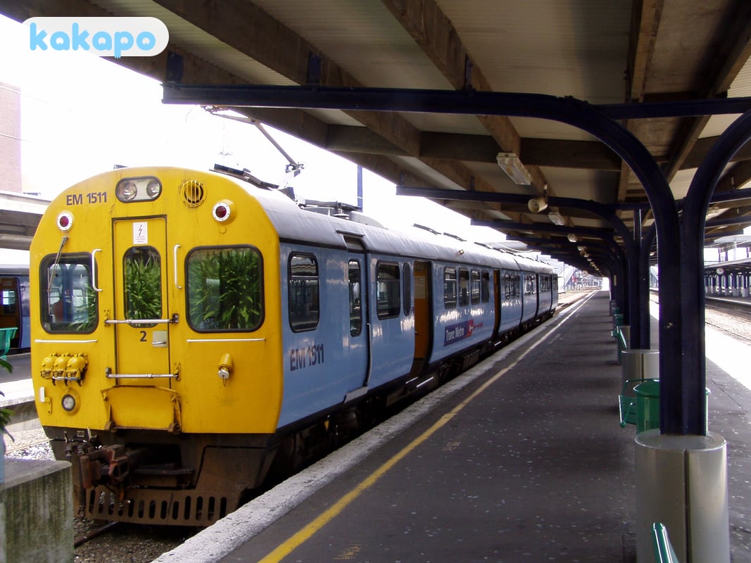
- Metlink: integrated bus/train tap card (Snapper). Trains up to the Hutt Valley, Kapiti, Wairarapa.
- Buses: extensive network; runs late on weekend nights.
- Wellington Airport (WLG): 8 km southeast. Airport Express bus to CBD NZ$13 (25 min). Taxi NZ$30-40. Uber NZ$25-35. The runway sits between Cook Strait and the harbour — hold-off landings in crosswinds are routine.
- Driving: drive on the LEFT. Wellington's narrow hill streets surprise visitors from right-driving countries.
- Cycling: getting better, but the wind and the hills make it tough. Helmet legally mandatory.
- Walking the harbour: the waterfront promenade from Te Papa to Oriental Bay is flat, scenic, well-lit at night.
Weather, UV, and what to pack
- Summer (Dec-Feb): 18-22°C; long daylight (sunset 21:00+); often windy but warm.
- Winter (Jun-Aug): 8-12°C; rarely freezes; snow extremely rare in CBD; wet and grey.
- UV: NZ has the world's strongest UV. SPF50+ on exposed skin Oct-Mar.
- The "four seasons in a day" rule: layered clothing always. Waterproof shell mandatory year-round.
- Hiking around Wellington: Mt Victoria, Mt Kaukau, Eastern Walkway, Red Rocks coastal walk — all reachable from the CBD. Carry water, layer up; weather changes fast on the hilltops.
- Sun in winter: still strong despite the cold. Sunglasses on bright winter days.
Money, healthcare, emergency numbers
- Currency: NZ dollar (NZD). $1 USD ≈ NZ$1.70.
- Cards: contactless universal.
- Tipping: not customary; NZ hospitality wages are high.
- ACC: covers all visitors for accident treatment in NZ — but doesn't cover repatriation or non-accident illness. Travel insurance still essential.
- Emergency: 111 (police, fire, ambulance). Mobile 112 fallback.
- Hospital: Wellington Hospital (04 385 5999); Wellington After Hours Medical Centre (04 384 4944).
- Border biosecurity: declare all food and outdoor gear (boots, tents) at NZ arrival. NZ$400 instant fines.
- Te Papa: the national museum is free, world-class, and a perfect rainy-day option.
- SIM: Spark, One NZ, 2degrees at airport; or eSIM (Airalo NZ).
Frequently asked questions
Is Wellington safe to visit in 2026?
Yes — Wellington is one of the calmest capital cities anywhere. The US State Department lists New Zealand at Level 1 and the UK FCDO has no advisories. Crime against tourists is low, the central city is walkable, and police presence around Courtenay Place and Lambton Quay is visible. The honest concerns are environmental: Wellington is the windiest capital in the world by long-term average, sits across the Wellington Fault and the Hikurangi Subduction Zone, and weather routinely disrupts both Wellington Airport (WLG) and the Cook Strait ferry. Visitors who pack layers, build buffer time into ferry and connecting-flight bookings, and know the Drop-Cover-Hold-On drill will be fine.
Is Wellington safe at night?
Yes — the waterfront promenade from Te Papa to Oriental Bay is flat, well-lit, and busy until late. Courtenay Place is the bar strip and gets rowdy on Friday and Saturday after 2am closing, with the standard cluster of assault and drunk-and-disorderly incidents that any capital nightlife strip produces. CCTV is comprehensive and police are visible. Walk in company, don't engage with intoxicated aggression, and book a rideshare home rather than crossing Mt Victoria on foot. Cuba Street, the alternative-vibe pedestrian strip, is safe day or night. There are no genuinely dangerous neighbourhoods in central Wellington.
Is Wellington safe for solo female travellers?
Yes — New Zealand ranks consistently near the top of solo-female-travel safety indices and Wellington is one of its safer cities. Street harassment is uncommon, the Metlink network runs late on weekend nights, and the compact CBD means you rarely walk more than fifteen minutes between bars, hotels and the waterfront. The standard advice applies on Courtenay Place at 2am — keep drinks supervised, walk in groups, use a known rideshare back. The genuine environmental risks (wind, earthquakes, the Cook Strait ferry crossing) are non-gendered.
Can you drink tap water in Wellington?
Yes — Wellington's tap water is treated to New Zealand drinking-water standards and is safe across the city, Hutt Valley, and Porirua. Wellington Water publishes annual compliance reports. Pressure issues and occasional boil-water notices in specific suburbs after pipe bursts do occur (the network is aging and under upgrade) but these are localised and well-publicised when they happen. Carry a refillable bottle — tap is the norm in restaurants and is offered free with meals.
What's the biggest scam to avoid in Wellington?
There isn't a meaningful scam culture in Wellington — petty fraud is rare and tourist-targeted cons effectively don't exist. The recurring practical traps are airport-area taxi overcharging if you skip the licensed rank in favour of a kerbside offer, and rental-car insurance upselling at depot pickup (read your existing travel-insurance excess clause before arriving). Cook Strait ferry tickets should be booked directly with Interislander or Bluebridge — third-party resellers occasionally add markup.
What should I do if there's an earthquake in Wellington?
Drop, Cover and Hold On — the same drill New Zealand teaches schoolchildren. Get under a sturdy desk or table, cover your head and neck, and hold on until shaking stops. Don't run outside during shaking; falling glass and masonry from heritage buildings cause most central-city injuries. If you feel strong shaking lasting more than a minute or shaking that makes it hard to stand, evacuate to high ground immediately afterwards — that is the trigger for self-evacuating from a possible tsunami, regardless of any official alert. New Zealand's Emergency Mobile Alert system pushes loud warnings to phones; you cannot miss it. Tsunami evacuation maps are posted along the waterfront.