

Is Christchurch, New Zealand Safe? A 2026 Travel Safety Guide
The 2011 earthquake legacy and ongoing rebuild, the southern alps day-trip drives, winter ice on Arthur's Pass, the Mosque attack memorial, and the realistic risks of South Island's gateway city.
Christchurch — population ~400,000, the South Island's largest city — is a calm and safe destination. The city is fundamentally a rebuilt one; the 22 February 2011 earthquake (M6.3, 185 deaths) and the larger Sept 2010 quake reshaped both the skyline and the civic mood.
The honest concerns now are mostly logistical. Parts of the central city are still rebuilding 15 years on. The seismic context remains live — aftershocks from the Canterbury sequence continue and the broader Alpine Fault to the west is overdue for a major rupture. Day-trips to the Southern Alps (Arthur's Pass, the TranzAlpine railway, Lake Tekapo) involve genuine alpine driving with winter snow and summer rockfall risks. Winter ice on Christchurch's flat suburban streets catches drivers out. The 15 March 2019 Al Noor and Linwood mosque attacks killed 51 — security and community feel were reshaped, and an annual public commemoration is held; visitors are welcome to attend respectfully.
The US State Department lists New Zealand at Level 1; UK FCDO has no advisories. Both note the standard earthquake context.
| Scam / petty-crime risk | Medium |
|---|---|
| Violent crime (tourists) | Low |
| Safer neighbourhoods | Riccarton, Merivale |
| Data sources cited | 4 |
| Last verified |
What the score means — 91/100
- Personal safety (93) — high. Petty crime is the main risk; violent crime against tourists is rare.
- Transport (86) — bus network (Metro Christchurch); compact CBD; airport 12 km from centre; no rail to airport.
- Healthcare (90) — Christchurch Hospital is the South Island's main referral centre.
- Air quality (90) — generally excellent; winter wood-smoke (chronic Canterbury inversion issue) can push PM2.5 unhealthy on still cold nights.
The 2011 earthquake legacy and ongoing seismic risk
The Canterbury earthquake sequence began with the 4 September 2010 M7.1 Darfield event. The 22 February 2011 M6.3 aftershock — closer to the city, shallow, with vertical ground accelerations exceeding 2g — caused the catastrophic damage and 185 deaths, including 115 in the CTV Building collapse. June 2011 and December 2011 events caused further damage.
- What you'll still see: vacant lots in the CBD, "Cardboard Cathedral" (the temporary transitional cathedral by Shigeru Ban — still in use), the unfinished restoration of the original Christ Church Cathedral (work continues with completion expected late this decade).
- Earthquake memorial: the Oi Manawa Canterbury Earthquake National Memorial along the Avon River — engraved with all 185 names. Visitable, free, moving.
- Quake City museum: small, focused exhibition at Canterbury Museum's pop-up — recommended for context.
- Ongoing seismic risk: Canterbury aftershocks continue at low rate. The Alpine Fault to the west is the bigger concern — it ruptures on average every 250-300 years, with the last major event in 1717. A future Alpine Fault event is one of NZ's largest single hazard scenarios, with Christchurch impact being severe shaking but not direct rupture.
- What to do: Drop, Cover, Hold On. Don't run outside.
- Phone alerts: NZ's Emergency Mobile Alert system pushes warnings to phones in the affected area.
- Tsunami: New Brighton and the eastern coastal suburbs have evacuation maps. Strong shaking + coast = high ground immediately.
The rebuild — what's open and what's still going
- What's complete: Te Pae Convention Centre (2022); Christchurch Stadium plans (Te Kaha, opening 2026); Avon River precinct; Margaret Mahy playground.
- Cathedral Square: still has the partially restored Christ Church Cathedral surrounded by hoardings; the work is steady but slow.
- Re:Start container mall era: closed in 2018 once permanent retail returned. The pop-up era of the rebuild is over.
- Cordoned areas: a few sites remain fenced; signage is clear. Don't enter cordoned construction zones.
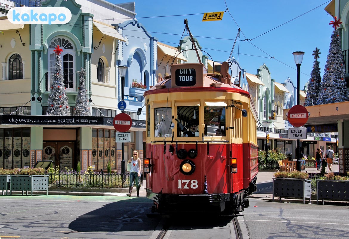
- Heritage tram: returned post-quake, now runs the inner-city loop; safe and tourist-friendly.
- EQC and insurance scars: many private homes still bear visible damage 15 years on; this is part of the city's character.
Southern Alps day-trips — Arthur's Pass, Lake Tekapo
- Arthur's Pass (SH73): 2.5 hours west to the alpine pass village; classic NZ alpine drive. Sealed but winding; subject to closures for snow, ice, and rockfall.
- TranzAlpine train: Christchurch to Greymouth via Arthur's Pass — one of the world's great rail journeys (~5 hours each way). Safer than driving for non-alpine-experienced visitors. NZ$219 each way standard.
- Akaroa / Banks Peninsula: 90 min east; calm winding hills, dolphin-watching tours; weather mild.
- Lake Tekapo and Mt Cook: 3 hours southwest; the Church of the Good Shepherd, the Mt John observatory, lupins in November, dark-sky reserve. SH8 driving generally easy but watch for ice in winter.
- Winter driving: chains required at Arthur's Pass and other alpine routes after snow. Most rentals provide; check policy.
- Don't drive Arthur's Pass in heavy snow without alpine experience. Tour buses and the train are safer.
- Hiking: alpine weather changes fast. Check NZ MetService and DOC track conditions before going. Carry PLB on serious tramps (DOC visitor centres rent for ~NZ$10/day).
Winter ice in the city — the surprising hazard
- Christchurch winters: -2 to 12°C typical; clear cold nights produce hard frost on flat suburban streets.
- Black ice: pre-dawn drives (e.g. early Mt Cook departures) routinely cross black ice on country roads. Speed limits don't account for it.
- Bridges freeze first: standard advice.
- Pedestrian falls: ED visits spike in cold snaps. Winter boots with grip.
- Heating: many older homes are poorly insulated; bring warm sleepwear if staying in budget accommodation.
- Snow in the city: rare (every 2-5 years). When it happens, the city briefly stops — buses suspended, schools closed.
The 2019 Mosque attacks — the memorial and visiting respectfully
On 15 March 2019, a single attacker killed 51 worshippers at the Al Noor Mosque (Deans Avenue) and Linwood Islamic Centre. The attack reshaped New Zealand's gun laws and the city's collective mood.
- The annual commemoration: held on 15 March in Hagley Park; public; respectful attendance welcomed.
- Al Noor Mosque: a working mosque; visitors are welcome at appropriate times. Dress modestly; cover hair (women); follow the Imam's direction.
- Christchurch Botanic Gardens / Hagley Park: opposite Al Noor. Permanent flower memorials and informal tributes.
- The city's response: visible across the central city — hijab solidarity displays, community-funded gardens, public art. Many international visitors find it the most distinctive aspect of modern Christchurch.
- Don't conflate: Christchurch is not less safe because of this attack. NZ tightened gun laws within weeks; the city has an active, integrated Muslim community now larger than before.
Areas — CBD, Riccarton, Sumner, New Brighton
Recommended bases: CBD / Cathedral Square area — central, mid-range hotels, walkable to museums and Hagley Park. Riccarton — leafy university-adjacent suburb, 10 min west of CBD; cafés and the Riccarton Mall. Merivale — upscale residential, near Hagley Park north. Sumner — beachside village 25 min east; cliffwalk and surf school. New Brighton — quieter beach suburb, hot saltwater pools.
Stay aware: Linwood and Aranui after dark have higher property-crime rates; nothing tourist-targeting. The CBD at 02:00 (Strip on Manchester Street near Cathedral Square) has the standard late-night nightlife cluster.
Money, transport, emergency numbers
- Currency: NZ dollar (NZD). $1 USD ≈ NZ$1.70.
- Cards: contactless universal.
- Tipping: not customary.
- Christchurch Airport (CHC): 12 km northwest. Metro bus 29 to CBD NZ$5 (35 min); shuttle ~NZ$25; taxi NZ$50; Uber NZ$30-40.
- Driving: drive on the LEFT. Christchurch is grid-flat — easy compared to Wellington's hills.
- Cycling: Christchurch has NZ's best urban cycle network — Avon River Trail, Major Cycleways. Helmet legally mandatory.
- Emergency: 111 (police, fire, ambulance). 112 mobile fallback.
- Hospitals: Christchurch Hospital (03 364 0640); 24-Hour Surgery (03 365 7777).
- Border biosecurity: declare all food and outdoor gear at arrival. NZ$400 instant fines.
- SIM: Spark, One NZ, 2degrees at airport; or eSIM (Airalo NZ).
Frequently asked questions
Is Christchurch safe to visit in 2026?
Yes — Christchurch is a calm, very safe city. The US State Department lists New Zealand at Level 1 and the UK FCDO carries no advisories. Crime against tourists is rare and police presence is visible across the rebuilt CBD. The realistic concerns are logistical and environmental: parts of the central city are still rebuilding fifteen years on from the 2010-2011 Canterbury earthquake sequence, aftershocks continue at low rate, the Alpine Fault to the west is overdue for a major rupture, and day-trips into the Southern Alps involve real winter driving conditions. None of this should deter a visit; it just shapes how you plan it.
Is Christchurch safe at night?
Yes — the central city is calm after dark and the Hagley Park / Cathedral Square area is well-lit and quiet. The Manchester Street / Strip nightlife cluster around 2am has the standard late-night incidents any provincial capital produces, but nothing tourist-targeting. Linwood and Aranui suburbs have higher property-crime rates after dark but no tourist relevance. Walk in company on bar nights, use Uber rather than crossing dark suburban streets, and you'll have no trouble. The flat grid makes navigation easy compared to hilly Wellington.
Is Christchurch safe for solo female travellers?
Yes — New Zealand ranks high on solo-female-travel safety indices and Christchurch is one of its safer cities. Street harassment is uncommon, the Metro bus network is reliable into the evening, and the compact CBD and Hagley Park area are easy to walk in daylight. The standard advice applies on Manchester Street at 2am — book a known rideshare home rather than walking solo. On alpine day-trips, the TranzAlpine train and coach tours are noticeably safer than solo winter driving for visitors not used to ice and chains.
Can you drink tap water in Christchurch?
Yes — Christchurch tap water is famously among the best in the world, drawn from aquifers under the Canterbury Plains and historically supplied untreated. After the 2010-2011 earthquakes some bores were temporarily chlorinated for safety; the city is progressively returning to untreated supply where infrastructure allows. Either way the water meets New Zealand drinking-water standards and is safe everywhere. Restaurants offer it free with meals; carry a refillable bottle.
What's the biggest scam to avoid in Christchurch?
Christchurch has no significant scam culture. The recurring practical traps are airport-taxi overcharging if you bypass the licensed rank (use the Metro 29 bus to the CBD for NZ$5 or Uber for around NZ$30-40 instead) and rental-car insurance upselling at depot pickup — the cheap headline rate often comes without a meaningful excess waiver. For alpine day-trips, book the TranzAlpine train and Mt Cook coach tours through the operators directly rather than third-party resellers who add markup.
Is the earthquake risk still serious in Christchurch?
Yes, but in a managed way. The Canterbury aftershock sequence continues at low rate fifteen years after the 22 February 2011 M6.3 event. The bigger concern is the Alpine Fault to the west, which ruptures on average every 250-300 years with the last major event in 1717 — a future Alpine Fault earthquake would produce severe shaking in Christchurch but not direct surface rupture. New buildings since 2011 are built to upgraded seismic codes; some older heritage stock has been retrofitted and some condemned. Drop, Cover, Hold On is the drill. New Zealand's Emergency Mobile Alert system pushes loud warnings to phones, and tsunami evacuation maps cover New Brighton and the eastern coastal suburbs.