

Is Seattle, United States Safe? A 2026 Travel Safety Guide
The Pacific rain, the visible homelessness crisis, summer wildfire smoke, the Cascadia earthquake context, and the realistic risks of Washington's biggest city.
Seattle is generally safe for tourists in tourist neighbourhoods. Crime against visitors is uncommon. The realistic risks are environmental and sociological: the genuinely heavy Pacific rain (~150 rainy days/year), the visible homelessness and addiction crisis in some downtown corridors (3rd Ave, parts of Pioneer Square — confronting, not violent towards passers-by), the summer wildfire smoke that has become a regular feature, and the longer-term Cascadia subduction-zone earthquake context.
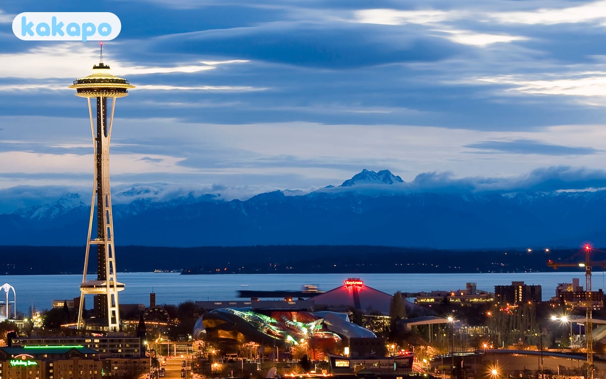
The honest framing for first-time visitors: Seattle is medium-large (~750,000 in city, 4 million metro), built on hills between Puget Sound and Lake Washington. Pike Place Market, the Space Needle / Seattle Center, Pioneer Square, the waterfront, Capitol Hill, Fremont, and Ballard are the visitor anchors. Mt Rainier (90 min south-east), the Olympic Peninsula, and the San Juan Islands are nearby reward day or overnight trips.
The 2026 context worth knowing: Washington's 2021 drug-decriminalisation experiment was effectively rolled back when the legislature passed and the governor signed HB 2024 in May 2023, returning simple possession to a gross misdemeanour with arrest authority restored. Visible street-drug use in downtown corridors has reduced from the 2022 peak but remains the most confronting tourist-area issue. Sound Transit's Link light rail expansion (the East Link to Bellevue and Redmond opened 2024) has changed the airport-to-city calculation — SEA to downtown is still the same $3.50 trip, but you can now reach the Eastside tech corridor without driving. Hotel prices have not really come back down from the post-pandemic resort-fee era — expect $200-400/night in central neighbourhoods, more in summer.
| Scam / petty-crime risk | Medium |
|---|---|
| Violent crime (tourists) | Low |
| Most common scams | visible street-drug activity in the 3rd Avenue corridor; aggressive begging in downtown corridors; open drug use in parts of Capitol Hill |
| Safer neighbourhoods | Belltown, South Lake Union, Capitol Hill |
| Data sources cited | 4 |
| Last verified |
What the score means — 82/100
- Healthcare (90) — Harborview, UW Medical Center, Virginia Mason are excellent.
- Air quality (84) — usually clean Pacific air. Wildfire-smoke episodes (Aug-Sep) drop AQI sharply.
- Transport (84) — Link light rail + buses + ferries integrated; rideshare ubiquitous.
- Personal safety (78) — pulled down by visible-distress areas; tourist neighbourhoods are safer than the headlines suggest.
The rain — Pacific Northwest reality
- Rainfall: ~950 mm/year across ~150 days. Lighter than Bergen, heavier than London.
- Pattern: October-April is wet (frequent light rain, occasional heavy). Summer (July-September) is often genuinely dry.
- Locals don't carry umbrellas: they wear waterproof jackets.
- What to bring: a proper waterproof jacket, waterproof shoes, layered clothing.
- Snow: rare in the city; common in nearby Cascades.
- Best summer: July-September. 18-28°C. Dry.
The homelessness crisis — the honest view
Like SF and LA, Seattle has a visible homelessness and addiction crisis. The relevant context for tourists:
- Where it's most visible: 3rd Avenue downtown corridor (between Westlake and Pioneer Square). Chinatown-International District some streets. Some parts of Capitol Hill.
- Risk to tourists: violent crime against passers-by is rare. Aggressive begging happens. Open drug use is visible.
- What to do: walk briskly through the affected corridors; rideshare during distance gaps if uncomfortable.
- Don't photograph people in distress.
- The CHOP/CHAZ context (2020): long over. The area has returned to normal city life.
Wildfire smoke — August-September reality
- Pacific Northwest wildfires: smoke from BC and eastern Washington fires drifts into Seattle several weeks each summer.
- AQI spikes: can reach hazardous levels (300+).
- Effects: eye irritation, sore throat, cough. Asthmatics: bring inhalers.
- If AQI is hazardous: indoor activities, N95 masks if outside.
- Apps: AirNow, IQAir.
- Visibility on smoky days: Mt Rainier disappears; outdoor sightseeing pointless.
Cascadia earthquake context
- The Cascadia subduction zone: 1,000-km fault off the BC and Pacific Northwest US coast. Capable of magnitude 9 earthquakes.
- Long-term probability: ~10-15% in next 50 years.
- Day-to-day tourist risk: small for short-trip visitors.
- If a strong earthquake hits: drop, cover, hold; if outdoors near coast, head inland and to high ground (tsunami risk).
- Modern Seattle buildings: post-2000 are built to current code.
Areas — where to base, where to be aware
Recommended for visitors: Belltown (downtown adjacent, walkable), South Lake Union (modern, Amazon-area), Queen Anne (residential, Space Needle side), Capitol Hill (gay-friendly, nightlife), Fremont (quirky, the Troll), Ballard (gentrified Scandinavian heritage).
Stay aware: 3rd Avenue downtown corridor, parts of Pioneer Square at night (daytime fine for the historic core; nighttime sketchier), parts of the Chinatown-ID at night.
Mt Rainier and the day trips
- Mt Rainier National Park: 90 min south-east. America's most prominent volcanic peak (4,392 m).
- Driving: scenic, manageable in summer. Snow chains required Nov-April on park roads.
- Hiking at altitude: trails climb to 2,000+ m. Layered clothing; weather changes fast.
- Don't summit Rainier without proper experience: serious mountaineering with crevasse risk; a few climbers die each year.
- Olympic Peninsula: 4-hour drive (with ferry options). Hoh Rainforest, Hurricane Ridge.
- San Juan Islands: ferry from Anacortes (90 min north). Whale watching.
Transport, ferries, the airport

- Link light rail (Sound Transit): connects airport to downtown. Useful and reliable. $3-3.50.
- Buses (King County Metro): extensive.
- Washington State Ferries: car and passenger ferries to Bainbridge Island, Bremerton, Vashon. The 35-min Bainbridge crossing is a great local view.
- Streetcar: South Lake Union and First Hill lines.
- Uber + Lyft: ubiquitous.
- Sea-Tac Airport (SEA): 21 km south. Link light rail $3.50 to centre, 40 min — easy.
Money, food, the cost story
- Currency: US dollar.
- Tipping: 18-22%.
- Tax: 10.25% Seattle sales tax. Hotels add ~16%.
- Cost: hotels $200-400/night standard.
- Tap water: excellent.
- Local food: salmon (especially at Pike Place), Dungeness crab, oysters, coffee (the original Starbucks; better at independents).
Neighbourhood-by-neighbourhood breakdown
- Downtown + Pike Place Market — the visitor anchor. Pike Place itself (the 1907 farmers' market with the fish-throwers at Pike Place Fish Co, the original Starbucks on 1912 Pike Place, the gum wall under the arcade) is busy and well-policed every day. The 3rd Avenue corridor between Westlake and Pioneer Square is the most-confronting stretch of visible street-drug activity in the central city — walk briskly through, don't dwell, and you'll be unharmed. The 1st Avenue and 2nd Avenue parallels are cleaner.
- Belltown — downtown-adjacent residential-and-restaurant grid north of Pike Place. The Pink Door, Tilikum Place Café, Ohana, plus high-rise condos. Walkable to Pike Place and the Space Needle. A practical first-night base; hotels $200-350.
- Capitol Hill — the gay-friendly nightlife and food hub up the hill east of downtown. Pike/Pine corridor, Cal Anderson Park, Elliott Bay Book Co, Quinn's, Oddfellows. Walk-back-to-downtown distance is 25 minutes through dim streets; rideshare after midnight. The 2020 CHOP/CHAZ era is long over and the area has returned to normal city life.
- South Lake Union (SLU) — the Amazon-built modern grid north of downtown. Hilton, MOHAI museum, the South Lake Union Streetcar. Calm, walkable, family-friendly; restaurants like RN74 and Westward (just north). Easy Link light rail access via Westlake.
- Ballard — the gentrified Scandinavian-heritage neighbourhood north-west. Ballard Locks (where boats transit between Puget Sound and Lake Union, plus the salmon ladder), Ballard Sunday Farmers Market, Old Ballard's bar strip on Ballard Avenue. A 25-minute bus or Uber from downtown; calm at night.
- Fremont — the "Centre of the Universe", quirky and walkable. The Fremont Troll under the Aurora Bridge, the Lenin statue, Fremont Brewing, Theo Chocolate factory tour. Adjacent to the Burke-Gilman Trail along Lake Union.
- U-District (University of Washington) — the campus and the streets immediately east of I-5. UW campus is beautiful in cherry-blossom season (late March); University Way (the Ave) has cheap student food. Link light rail U District station opened 2021; 8 minutes from Westlake.
- Pioneer Square — the historic 1890s core south of downtown. The Underground Tour (rebuilt city after the 1889 fire), Smith Tower observatory, Klondike Gold Rush museum. Daytime fine; nighttime sketchier on some adjacent streets — stick to lit main arteries and use rideshare.
- Link light rail — Sound Transit's spine. The 1 Line runs Northgate-Lynnwood through downtown and U District to SeaTac airport ($3.50, 40 min airport-to-Westlake). The 2 Line (East Link) opened 2024 and reaches Bellevue and Redmond; full Westlake-to-Redmond connection completes in 2025.
- SeaTac Airport and Highway 99 north — SEA is 21 km south of downtown via Link or I-5. Highway 99 (Aurora Avenue) is the older surface road; some stretches north of the centre (Aurora between 85th and 145th) have visible street-prostitution and motel-strip issues — not relevant to tourists unless you accidentally book a budget motel on that strip. The drive to the North Cascades National Park goes north on I-5 then east on Highway 20.
- I-5 vs I-405 — I-5 runs through downtown and is the always-congested main route. I-405 loops east through Bellevue and Renton and is the rush-hour alternative. Both are slow 7-9am and 3-7pm weekdays; expect 90+ minutes for a 25-mile drive at peak.
- The houseless reality, honestly — Seattle has a visible houseless and addiction crisis comparable to Portland or SF, concentrated along 3rd Avenue downtown, parts of Pioneer Square at night, some Chinatown-International District blocks, and the Aurora/Highway 99 corridor north. Encampment sweeps under Mayor Harrell have reduced the most-visible tent clusters but the underlying crisis persists. Risk to passers-by is low — aggressive begging and open drug use are the confronting elements, violent crime against tourists is rare. Walk briskly, don't photograph people in distress, use rideshare to bridge uncomfortable distances.
If it's your first time visiting
- Best arrival: Link light rail from SeaTac (SEA) is the clean answer — $3.50 contactless tap, 40 minutes to Westlake station in the heart of downtown, trains every 8-10 minutes. Avoid the airport taxi queue and the $50-70 Uber/Lyft surge during peak hours. The 2 Line (East Link) opened 2024 if you're staying in Bellevue or Redmond.
- Best neighbourhood for your first night: Belltown or South Lake Union for walkability to Pike Place and the Space Needle without crossing the 3rd Avenue corridor at night. Hotels Andra, Edgewater, Pan Pacific, Hyatt House SLU all run $200-350. Skip the cheaper motels on Aurora (Highway 99) north — they're a hard-context strip.
- Pike Place Market timing: arrive by 9am on a weekday for the fish-throwers at Pike Place Fish Co before the crowds, or after 5pm when day-trippers leave. The original Starbucks line at 1912 Pike Place wraps around the block at peak — skip it, the coffee is identical to any Starbucks.
- Buy a serious rain shell, not an umbrella — locals don't carry umbrellas. October-April brings ~150 rain days a year, mostly light persistent drizzle. A Patagonia / Arc'teryx / REI-brand waterproof shell ($150-300) plus waterproof shoes makes the difference between a miserable trip and a normal one. REI's flagship at 222 Yale Ave N is itself a Seattle attraction.
- Pre-book the Space Needle and Chihuly Garden combo — $48 for both, timed entry, sells out summer afternoons. The Space Needle alone is $39; Chihuly Garden and Glass next door is the better photographic experience. Pike Place Market is free.
- Food beyond the Pike Place tourist circuit: Salumi (cured meats, founded by Mario Batali's father), Bateau (steak), Canlis (fine dining with a Lake Union view, $200+ tasting menu), Westward (Lake Union seafood), The Walrus and the Carpenter (Ballard oyster bar). For coffee, skip the original Starbucks and try Victrola, Storyville, Caffé Vita, or Espresso Vivace on Capitol Hill — Seattle's third-wave coffee is the actual local culture.
- Wildfire-smoke check (August-September): AirNow or IQAir before outdoor plans. On hazardous days (AQI 300+), Mt Rainier disappears, your eyes burn, and outdoor sightseeing is pointless — pivot to MOHAI, the Underground Tour, Chihuly Garden, the Seattle Art Museum, or the Pacific Science Center. N95 masks are useful.
- Mt Rainier day trip: 90 minutes south-east via Highway 7 or 410 to Paradise visitor centre (5,400ft); snow chains required November-April on park roads. Pre-book a timed-entry permit May-September (Recreation.gov, $2 reservation fee) — implemented 2024 to manage overcrowding. Don't attempt the summit without proper mountaineering experience; a few climbers die each year on the crevasse-laced glacier routes.
- Common rookie mistakes: walking the 3rd Avenue corridor between Westlake and Pioneer Square at 11pm (confronting; rideshare instead); driving downtown without booking parking (rates $30-45/day in central garages); booking a SeaTac airport hotel and assuming it's close to downtown (it's 21 km south); ignoring the $0 sales tax assumption (Seattle is 10.25% plus 16% hotel tax); tipping at 15% (Seattle expects 18-22%); planning a Mt Rainier visit without checking road status (the Paradise road closes overnight in winter); and assuming the Bainbridge Ferry is a quick errand (the 35-minute crossing each way is the experience, plan 3-4 hours round-trip).
Practical info — emergency numbers
- Emergency: 911.
- Seattle Police non-emergency: 206-625-5011.
- Harborview Medical Center ER: 206-744-3000.
- UW Medical Center ER: 206-598-3300.
Bring: a serious waterproof jacket and footwear (Oct-April), layered clothing, comfortable walking shoes, an unlocked phone (T-Mobile, AT&T, Verizon), a contactless card, and US-valid travel insurance with full medical coverage.
Frequently asked questions
Is Seattle safe to visit in 2026?
Yes — Seattle is generally safe in tourist neighbourhoods. Crime against visitors is uncommon and the central anchors (Pike Place Market, the waterfront, Belltown, South Lake Union, Queen Anne, Capitol Hill, Fremont, Ballard) are calm. The realistic concerns are environmental and sociological: heavy Pacific rain from October to April (about 150 rainy days a year), a visible homelessness and addiction crisis along the 3rd Avenue downtown corridor and parts of Pioneer Square (confronting rather than violent towards passers-by), summer wildfire smoke that has become a near-annual feature in August and September, and the long-term Cascadia subduction-zone earthquake context.
Is Seattle safe at night?
Yes in most tourist neighbourhoods. Belltown, Capitol Hill, Fremont, Ballard and the waterfront are calm after dark. The exceptions are the 3rd Avenue corridor between Westlake and Pioneer Square (open drug use, aggressive begging, confronting but rarely violent), parts of Pioneer Square at night (the historic core is fine by day; some adjacent streets get sketchier after dark), and parts of the Chinatown-International District. Walk briskly through the affected blocks, use Uber or Lyft for distance gaps, and Link light rail is reliable into the evening. The CHOP/CHAZ era from 2020 is long over.
Is Seattle safe for solo female travellers?
Yes — Seattle is one of the easier US cities for solo female travel. The Link light rail is clean and reliable, Pike Place Market and the Space Needle area are busy all day, and the coffee-shop and bookshop culture means you'll rarely be the only solo person in a place. Standard precautions apply along 3rd Avenue, around some Pioneer Square blocks after dark, and walking home from Capitol Hill bars at 2am. The Pacific rain is the more practical concern — a proper waterproof jacket and shoes are essential October to April.
Can you drink tap water in Seattle?
Yes — Seattle tap water comes from the protected Cedar River and South Fork Tolt watersheds, is treated by Seattle Public Utilities, and is genuinely excellent. It is safe everywhere in the city. Restaurants offer it free with meals; a refillable bottle is fine. On Olympic Peninsula and Cascades hikes treat any stream water as you would anywhere in bear country.
What's the biggest scam to avoid in Seattle?
Seattle has very little organised scam culture. The recurring practical traps are unofficial "private" Mt Rainier tour brokers (book licensed operators like Evergreen Escapes or Tours Northwest directly), and Sea-Tac airport taxi offers (the Link light rail from SEA to downtown is $3.50 and 40 minutes, or use a metered Uber/Lyft from the rideshare pickup zone). Hotel resort fees and the 10.25% Seattle sales tax plus expected 18-22% tip can stack up — confirm what's included before booking.
What about wildfire smoke and earthquake risk?
Wildfire smoke is now an annual August-September feature. Smoke from BC and eastern Washington fires drifts into Seattle for one or two weeks most summers, occasionally pushing AQI into hazardous levels (300-plus). Check AirNow or IQAir before outdoor plans, bring N95 masks if travelling in late summer, and on smoky days indoor activities (museums, the Underground Tour, Chihuly Garden) work fine while Mt Rainier becomes invisible. The Cascadia subduction zone is a real long-term hazard — scientists estimate a 10-15% chance of a magnitude-9 event in the next 50 years — but day-to-day risk for a short visit is small. If strong shaking does happen, drop, cover and hold under sturdy furniture; if outdoors near the coast head inland and to high ground for tsunami.