

Is Vancouver, Canada Safe? A 2026 Travel Safety Guide
The Downtown Eastside reality, Pacific rain, bears in the parks, the Cascadia earthquake context, and the realistic risks of one of Canada's loveliest cities.
Vancouver is one of the safer large cities in North America for tourists. Crime against visitors is uncommon. The realistic risks are sociological and environmental rather than crime: the Downtown Eastside (the few-block stretch around East Hastings is North America's most visible homelessness, mental-illness, and opioid-overdose crisis — confronting to walk through but not violent towards passers-by), the genuine Pacific rain (Vancouver gets ~1,200 mm/year — twice London), bears in the surrounding parks (Capilano, Grouse, North Shore), and the Cascadia subduction-zone earthquake risk (long-term, low-day-to-day).
Canada sits at Level 1 on the US State Department's advisory list. UK FCDO is the same. The honest framing for first-time visitors: Vancouver is large (~675,000 in city, 2.6 million metro), built on a harbour with mountains rising directly behind. Stanley Park, Granville Island, Gastown, the seawall, and the day trips to Whistler, North Shore mountains, Vancouver Island are the visitor anchors.
Visiting Vancouver for the first time, the thing that catches most travellers off-guard isn't crime — it's the Pacific Northwest weather and how genuinely outdoorsy the city is. October-April brings 200+ rainy days; locals shrug and go hiking anyway. Vancouverites are friendly-but-reserved, with a strong sub-culture of yoga, kayaking, snowboarding, and conversations that quickly migrate to recommending hiking trails. The greeting is "Hi" or "Hey" — Canadians are polite-direct; "Thanks!" closes everything. A pour-over coffee at a local roaster (49th Parallel, Revolver, Pallet) is CAD 5-7, a sushi roll at Miku or Tojo's CAD 25-45 per person, casual dinner main CAD 28-42, a craft pint at a Mount Pleasant brewery CAD 9-12, a SkyTrain ride CAD 3.20-5.60 depending on zones, a Whistler day-trip ski pass CAD 200+ in season.
In 2026, the specific things that have changed since pre-pandemic include: TransLink Compass tap-to-pay rolled out (CAD 3.20-5.60 single, CAD 11.55 day pass, includes SkyTrain, buses, SeaBus); the Broadway Subway Line is finally under construction with major disruption through 2027; the Downtown Eastside opioid-crisis severity remains the worst in North America with the post-2021 "decriminalisation" pilot ended in 2024 — the few blocks remain visibly distressing but tourist violence stays rare; the post-2023 short-term rental restrictions have reduced Airbnb inventory; and Vancouver has remained one of the world's most expensive cities for accommodation — budget 30-40% more than equivalent US cities.
| Scam / petty-crime risk | Medium |
|---|---|
| Violent crime (tourists) | Low |
| Most common scams | aggressive begging in Downtown Eastside; pickpocketing in Downtown Eastside |
| Safer neighbourhoods | Downtown / Coal Harbour, West End, Gastown |
| Data sources cited | 4 |
| Last verified |
What the score means — 86/100
- Healthcare (90) — Canadian universal healthcare; Vancouver General is BC's flagship.
- Transport (88) — SkyTrain, buses, SeaBus all integrated and easy.
- Air quality (86) — generally clean; wildfire smoke episodes in summer.
- Personal safety (84) — high. Crime is concentrated in specific areas; tourist routes are very safe.
The Downtown Eastside — the honest description

This section is included because new visitors are often shocked by what they see and ask whether they're in danger. The honest answer is: confronting, not dangerous.
- Where: a 5-6 block stretch along East Hastings Street between roughly Carrall Street (the eastern edge of Gastown) and Main Street.
- What's there: hundreds of unhoused people, open drug use (fentanyl primarily), tent encampments, a visible mental-illness crisis. Canada's worst-affected open-air crisis area.
- Risk to passers-by: very low for violence — the population is overwhelmingly self-harming, not externally violent. Pickpocketing and aggressive begging do happen.
- What to do: walk through with a group if you must, in daylight. Gastown is fine; once you cross Carrall heading east you're in the affected area within a block.
- Better alternative: walk Gastown, then double back; reach Chinatown via Pender or Keefer rather than Hastings.
- Photography: don't photograph people in distress. Disrespectful.
- Why this exists: Canadian housing and addiction-treatment policy + decades of concentration of services in one neighbourhood. Ongoing public-policy debate.
Pacific rain and weather
- Rain: October-April is wet. Vancouverites use waterproof jackets, not umbrellas.
- Snow: rare in the city; common in the surrounding mountains. The North Shore ski resorts are 30 min from downtown.
- Best summer weather: June-September. 18-25°C, often dry.
- Wildfire smoke (August-September): BC interior fires drift smoke into Vancouver in some summers. AQI can spike severely. Asthmatics bring inhalers; heed advisories.
- The "atmospheric river" storms: rare but occur (November 2021 caused major flooding outside Vancouver). Travel advisories cover.
Bears, cougars, the parks
- Black bears: present in Stanley Park (rare), and routinely in Capilano, Lynn Canyon, Grouse Mountain, the North Shore.
- If you encounter one: don't run. Make yourself big. Speak calmly. Back away.
- Bear spray: legal in Canada; sold at MEC. Useful for backcountry hikes.
- Cougars: rarer; Vancouver Island and remote BC. If encountered: maintain eye contact, make yourself big, fight back if attacked.
- Coyotes: seen in Stanley Park; have approached people. Don't feed; back away.
- Hiking: stick to marked trails. Tell someone your plan. The North Shore Search and Rescue (NSR) is one of Canada's busiest because hikers underestimate the rainforest.
Cascadia earthquake context
- The Cascadia subduction zone: a 1,000-km fault off the BC and Pacific Northwest US coast. Capable of magnitude 9 earthquakes. Last major event was 1700.
- Probability: scientists estimate ~10-15% chance of a major Cascadia event in the next 50 years.
- Day-to-day risk: small for short-trip visitors.
- If a strong earthquake hits during your visit: drop, cover, hold under sturdy furniture; if outdoors, move away from buildings; if near coast, head inland and to high ground in case of tsunami.
- Modern Vancouver buildings: built to current seismic code. Pre-1980 buildings are weaker.
Transport and the airport
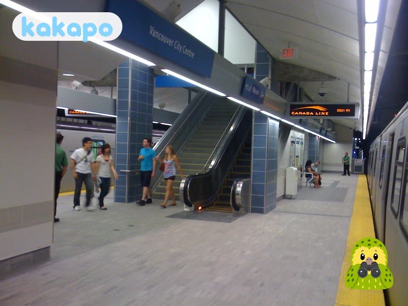
- SkyTrain: 3 lines, automated. Canada's largest driverless metro. Reliable.
- Buses: extensive. Tap a Compass card or contactless.
- SeaBus: ferry across Burrard Inlet to North Shore. Useful + scenic.
- Cycling: the seawall is one of the world's great urban-cycling routes. Mobi public bikeshare.
- Taxis + Uber + Lyft: all work.
- Vancouver Airport (YVR): 14 km south. Canada Line SkyTrain CAD $4.55-9.50 to downtown, 25 min — direct. Taxi/Uber CAD $35-50.
- To Whistler: 1h45m drive on the Sea-to-Sky Highway (one of the world's most scenic drives). Snowstorm in winter; chains/winter tyres required Oct 1 - Apr 30 on the Sea-to-Sky.
- To Vancouver Island: BC Ferries from Tsawwassen to Victoria, 1h45m crossing.
Money, food, the cost story
Neighbourhood-by-neighbourhood breakdown
- Downtown / Coal Harbour — the office towers, hotels, the convention centre, the seawall start. Very safe day and night. Excellent dining.
- West End — west of downtown, the dense residential beachfront neighbourhood adjacent to Stanley Park, the gay village around Davie Street. Very safe.
- Gastown — historic east of downtown, gentrified Victorian buildings, restaurants and bars, the Steam Clock. Lively at night, very safe. Borders the Downtown Eastside.
- Yaletown — south of downtown, converted warehouse district, upmarket restaurants, brick-lined alleys. Very safe.
- Kitsilano (Kits) — west of downtown across False Creek, beachfront, yoga-and-brunch culture, Kits Beach. Very safe.
- Granville Island — under the Granville Bridge, the public market, craft breweries, theatres. Day-trip destination, very safe.
- Commercial Drive ("the Drive") — east, multicultural, Italian-heritage, bohemian, craft coffee strip. Very safe with normal awareness.
- Mount Pleasant — south of False Creek, the craft brewery district, gentrified hip. Very safe.
- Main Street (South Main / SoMa) — south of Mount Pleasant, the second hip strip. Very safe.
- Downtown Eastside (East Hastings between Carrall and Main) — the few-block stretch of North America's most visible opioid-and-homelessness crisis. Confronting to walk through; not violent towards passers-by; passing through is fine, lingering is uncomfortable. Tourists who get off SkyTrain at Main Street-Science World and walk north will encounter it.
- North Shore (North Vancouver, West Vancouver) — across the harbour by SeaBus, Grouse Mountain, Capilano Suspension Bridge, Lonsdale Quay. Day-trip destinations, very safe.
If it's your first time visiting
- Best arrival airport: Vancouver International (YVR), 12 km south. To downtown: Canada Line SkyTrain CAD 11.05 in 25 min direct to Waterfront/Vancouver City Centre (the standard option), Uber/Lyft CAD 35-55, taxi CAD 45-55. YXX (Abbotsford) for some low-cost flights.
- Public transport: TransLink runs SkyTrain (3 lines), buses, SeaBus, West Coast Express. Compass tap-to-pay on every reader. CAD 3.20-5.60 single, CAD 11.55 day pass. Very useful — Vancouver isn't all walkable.
- Best neighbourhood for your first night: Downtown for centrality, West End for proximity to Stanley Park, Yaletown for upmarket, Kitsilano for beach vibe and brunch. Avoid first-time bookings in East Hastings.
- Day 1, jet-lag friendly: drop bags, lunch at a Coal Harbour or West End café (CAD 18-30), Stanley Park seawall walk or rented bike (10 km loop, 2 hours), early dinner at Miku or Tojo's for sushi (CAD 45-90 per person), evening drink at Yaletown or Gastown.
- Day 2 essentials: morning Granville Island market and craft breweries, North Shore mountain trip via SeaBus to North Vancouver and Grouse Mountain skyride (CAD 75) or Capilano Suspension Bridge (CAD 75), Commercial Drive for dinner.
- Day trips: Whistler (2h north via Sea-to-Sky Highway, skiing in winter, hiking in summer), Vancouver Island and Victoria (ferry from Tsawwassen, 95 min crossing + drive), Squamish (1h north, Chief mountain hike), Sea-to-Sky Gondola.
- Common rookie mistakes: not bringing rain gear (October-April is wet); driving the Stanley Park seawall (it's pedestrian/cycle only — walk or bike rental); skipping the SeaBus to North Vancouver (one of the world's most scenic commuter rides, CAD 3.20); leaving valuables in rental cars (car break-ins endemic at trailheads); going to the Downtown Eastside for Instagram opportunities (insensitive and tourist incidents do happen).
- Tap water is exceptional (Capilano and Seymour reservoirs). Drinkable everywhere.
- For wildlife in the surrounding parks: bears are real. Carry bear spray on Grouse or West Coast trails; make noise; don't run if encountered.
Practical info — emergency numbers
- Emergency: 911.
- Vancouver Police non-emergency: 604-717-3321.
- Vancouver General Hospital ER: 604-875-4111.
- North Shore Rescue: 911 (will dispatch).
Bring: a serious waterproof jacket if Oct-April, layered clothing, comfortable walking shoes, a contactless card, an unlocked phone (Bell, Rogers, Telus prepaid SIMs), and travel insurance with full medical coverage.
Frequently asked questions
Is Vancouver safe to visit in 2026?
Yes — Vancouver is one of the safer big cities in North America. Both the US State Department and the UK FCDO list Canada at Level 1. Crime against tourists is uncommon, the central anchors (Stanley Park, Gastown, Granville Island, the seawall, Yaletown) are calm, and the SkyTrain is among the cleanest, most reliable urban rail systems on the continent. The realistic concerns are the visible homelessness and opioid crisis on the Downtown Eastside, persistent Pacific rain October-April, periodic wildfire smoke in late summer, and the long-term Cascadia earthquake risk. None of this should deter a visit — just shape it.
Is Vancouver safe at night?
Yes — the seawall, Gastown, Yaletown and the West End are calm after dark. The SkyTrain runs late and is well-monitored. The exception is the East Hastings corridor between Carrall Street and Main Street, which is confronting rather than violent — open drug use, encampments and visible mental-illness crisis are concentrated there. Walk Gastown, then double back to your hotel rather than continuing east on Hastings, and reach Chinatown via Pender or Keefer. Take a taxi or Uber rather than walking through the Downtown Eastside at night.
Is Vancouver safe for solo female travellers?
Yes — Vancouver is one of the easier large cities globally for solo female travel. Street harassment is uncommon, the SkyTrain and SeaBus are reliable into the evening, and the seawall, Granville Island and Stanley Park are busy with locals all day. Standard advice applies near the Downtown Eastside, and on North Shore hikes (Grouse Grind, Lynn Canyon) tell someone your plan and stick to marked trails — North Shore Rescue is one of Canada's busiest SAR teams because the Pacific rainforest is easy to underestimate.
Can you drink tap water in Vancouver?
Yes — Vancouver tap water comes from the protected Capilano, Seymour and Coquitlam watersheds, is treated by Metro Vancouver, and is genuinely among the best municipal water on the continent. It is safe everywhere in the city and on the North Shore. Restaurants offer it free with meals. On backcountry hikes in the North Shore mountains, treat stream water — giardia is present.
What's the biggest scam to avoid in Vancouver?
Vancouver has very little organised scam culture. The recurring practical traps are airport taxi shortcuts (use the Canada Line SkyTrain for CAD $4.55-9.50 direct to downtown rather than negotiating fares at the curb) and unofficial Whistler day-tour brokers who quote a low headline price and add fees for the Sea-to-Sky drive. Book Whistler shuttles directly with Epic Rides or YVR Skylynx. On rentals, BC requires winter tyres or chains on the Sea-to-Sky Highway from October 1 to April 30 — make sure your rental complies before driving.
Should I be worried about the Downtown Eastside?
Confronting, not dangerous. The 5-6 block stretch along East Hastings between Carrall and Main is the most visible homelessness, addiction and overdose crisis in Canada, and new visitors are often shocked by what they see. The population is overwhelmingly self-harming rather than externally violent — risk to passers-by is very low for violence, although pickpocketing and aggressive begging do happen. Walk through in daylight with a group if you must, don't photograph people in distress, and use Pender or Keefer to reach Chinatown from Gastown rather than continuing east on Hastings. The area is the result of decades of concentrated services in one neighbourhood, not a security failure.