

Is Canberra, Australia Safe? A 2026 Travel Safety Guide
The 2003 and 2020 bushfire legacy, cold winter, the surrounding nature reserves, government-area photography, and why Canberra is one of the world's safest capitals.
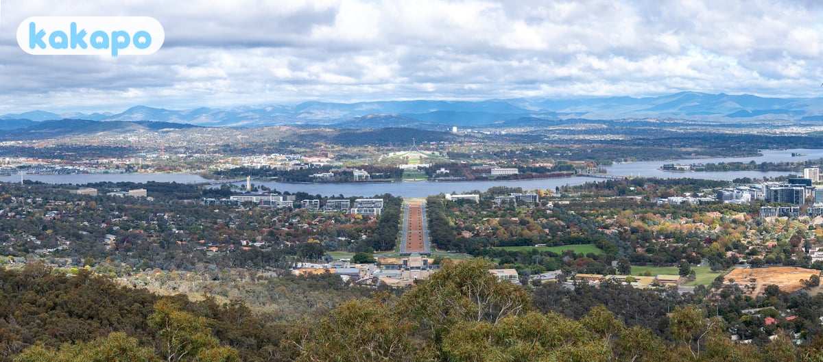
Canberra — population ~470,000, Australia's purpose-built capital in the Australian Capital Territory — is one of the world's safest capital cities. Crime is low; the planned-city layout (designed by Walter Burley Griffin) gives wide streets, abundant parkland, and a sub-million-population scale that produces a quiet, ordered feel. Most international visitors come for political/cultural pilgrimage (Parliament House, Australian War Memorial, National Gallery) plus the surrounding nature.
The honest concerns are environmental. The 2003 Canberra bushfire firestorm killed 4 in suburban Canberra (Duffy, Holder, Stromlo) and destroyed 470 homes — an event that reshaped Canberra's bushfire planning. The 2019-2020 Black Summer fires reached the southern ACT (Namadgi National Park largely burned; smoke from coastal fires gave Canberra the world's worst recorded air quality on multiple January 2020 days). Winter is cold by Australian standards (-5 to 12°C July-August; occasional snow at higher elevation; frost on suburban lawns most mornings June-August). The surrounding national parks (Namadgi, Tidbinbilla, Kosciuszko close by) involve serious bushwalking weather. And the government precinct (Parliament House Triangle, defence buildings) has photography and security rules that catch out unprepared visitors.
The US State Department lists Australia at Level 1; UK FCDO has no advisories. Both note the standard outdoor-weather and bushfire context.
| Scam / petty-crime risk | Low |
|---|---|
| Violent crime (tourists) | Low |
| Safer neighbourhoods | Civic, Kingston, Manuka |
| Data sources cited | 4 |
| Last verified |
What the score means — 93/100
- Personal safety (95) — exceptional. Crime against tourists is essentially nonexistent.
- Transport (86) — Canberra Light Rail (1 line opened 2019, expansion in progress); Transport Canberra buses; rental cars common; Canberra Airport (CBR) 8 km east.
- Healthcare (92) — Canberra Hospital and Calvary Hospital regional referrals; high-quality.
- Air quality (90) — generally excellent; bushfire-smoke episodes can be severe (2020 was historically so).
Bushfires — the 2003 firestorm and 2020 smoke legacy
Canberra has two defining bushfire events in living memory.
- 18 January 2003: a Saturday afternoon. Bushfires that had been burning for weeks in Namadgi and the surrounding ranges merged into a firestorm that broke through into suburban Canberra in 90 minutes. Fire reached suburbs of Duffy, Holder, Chapman, Kambah, Rivett, Weston Creek; 4 killed, 470 homes destroyed. The Mt Stromlo Observatory burned. The event reshaped Canberra's emergency planning, vegetation management, and building codes for fire-prone fringes.
- 2019-2020 Black Summer: didn't directly hit central Canberra but destroyed huge areas of Namadgi National Park (~80% burned) and Orroral Valley. Canberra's air quality on 1 January 2020 hit AQI 4,500+ (several times "hazardous" thresholds) — the world's worst recorded city air quality at that time. Tourists evacuated; outdoor events cancelled; the New Year's Eve fireworks were cancelled for the first time in decades.
- What you'll experience now: Namadgi NP regrowing; Orroral Valley still rebuilding; Tidbinbilla generally accessible. Some bushwalks closed during recovery.
- Future bushfire risk: ongoing. The ACT Emergency Services Agency issues fire ratings daily Nov-April. Catastrophic days = no entry to bushland.
- Smoke episodes: any future major fire in southern NSW or Victoria can put smoke over Canberra for days. N95 masks if sensitive.
- If a fire warning is issued: ACT Emergency Services Agency app pushes warnings; ABC Local Radio is the official emergency broadcaster.
Winter cold — Canberra is colder than people expect
- Numbers: June-August daytime 8-13°C; nights -5 to +5°C; frost on suburban lawns most mornings. Snow at Mt Ainslie summit and the Brindabella ranges occasional.
- Why it matters: tourists from tropical Australia and overseas underestimate. Canberra is on the Southern Tablelands at 580m elevation; the wind chill on Lake Burley Griffin in July is real.
- What to wear: layered clothing; warm jacket; gloves and beanie for evenings; closed shoes; rainproof shell.
- Indoor heating: most accommodation is well-heated, but older Canberra houses (and some heritage hotels) struggle in cold snaps; bring warm sleepwear.
- Frost on roads: black ice on rural roads (especially the road to Tidbinbilla and Kosciuszko); slow speeds.
- Best windows: October-November (spring — Floriade festival; tulips); March-April (autumn — golden trees); September-November and February-April for festivals.
- Summer (Dec-Feb): can be very hot (35-40°C heatwaves) but generally pleasant 25-32°C; bushfire risk peaks.
Parliament, War Memorial, gallery — security and etiquette
- Parliament House: free entry; security screening at entry (similar to airport — no liquids over 100ml, no sharp objects); free guided tours (45 min); House and Senate galleries when sitting (timetable at aph.gov.au).
- Photography at Parliament: permitted in most public areas (Marble Foyer, Great Hall, courtyards); restricted in Chambers when sitting; no photos of security personnel close-up.
- Don't bring: drones (prohibited over the Parliamentary Triangle without permit), large cameras may need declaration.
- Australian War Memorial: free entry; the Last Post Ceremony at 16:55 daily is moving; rebuilding works through 2027 may close some galleries — check website.
- National Gallery of Australia, National Library, Questacon, National Museum: all free or low-cost; standard museum etiquette.
- The Defence Headquarters (Russell): don't photograph perimeter or buildings; security responds.
- ASIO Headquarters: same rules; visible from Vernon Circle but don't approach with camera.
- Embassy Drive: ~80 embassies clustered around Yarralumla; photographing exteriors is generally fine; security at high-risk embassies (Chinese, Russian, US, Israeli, Indonesian) may ask questions.
Namadgi, Tidbinbilla, and the surrounding nature
- Namadgi National Park: south of Canberra; includes Mt Bimberi (ACT's highest at 1,913m); was 80% burned in 2020; recovery ongoing — many trails reopened, some still closed. Snow gum forests slowly regenerating.
- Tidbinbilla Nature Reserve: 40 min southwest of Canberra; eucalypt woodland with kangaroos, wallabies, koalas, platypus pools, the famous Sanctuary enclosure. Family-friendly; well-marked paths.
- Mount Ainslie: Canberra's iconic walk-up city viewpoint; 4 km loop; well-maintained; popular at sunrise/sunset.
- Mt Tidbinbilla and Mt Domain: more demanding alpine hikes; weather changes fast; carry water, layers, and tell someone your plan.
- Kosciuszko National Park: NSW alps 2 hr drive south; Mt Kosciuszko (Australia's highest peak, 2,228m) climbable from Thredbo or Charlotte Pass; serious alpine weather; PLB recommended for serious treks.
- Snake season: tiger snakes, eastern brown snakes active Sep-April; stick to paths; wear closed boots.
- Parks app: ACT Government Parks app for current alerts, closures.
Transport — light rail, buses, airport

- Canberra Light Rail: 1 line (Gungahlin to Civic — north Canberra to city centre); Stage 2A extension to Commonwealth Park opened 2024; future Stage 2B to Woden in planning. A$5.20 single tap. Useful for tourists going from city centre to Dickson area; otherwise limited.
- Transport Canberra buses: comprehensive but Canberra's spread-out planned-city layout makes some destinations (Tidbinbilla, the more distant museums) hard to reach without car.
- MyWay card: tap card; A$8 for a card; works on light rail and buses.
- Canberra Airport (CBR): 8 km east of city centre. Bus 11/11A to Civic A$5.20 (20 min); taxi A$30-40; Uber A$25-35.
- Driving: drive on the LEFT. Canberra's grid + circle road layout takes getting used to (Walter Burley Griffin's design produces some intersections that are unintuitive).
- Cycling: extensive bike paths; Canberra is genuinely bike-friendly; helmet legally mandatory.
- To Sydney: 3-hour drive on the Hume Highway / Federal Highway; coach (Murrays / Greyhound) 3.5 hr; train (NSW TrainLink XPLORER) 4 hr.
Where to stay — Civic, Kingston, Manuka

Recommended bases: Civic (Canberra City) — city-centre commercial district; walking to Lake Burley Griffin, museums; mid-range hotels (Hotel Realm, Crowne Plaza, Novotel). Kingston — leafy inner-south suburb; cafés, the Old Bus Depot Markets, walking distance to Parliament Triangle. Manuka — affluent inner-south; restaurants and cinemas; near Parliament House. Braddon / NewActon — design and hipster precinct; boutique stays.
There are no genuinely dangerous neighbourhoods in Canberra. Civic late-night sees the standard youth drinking scene around Garema Place; standard precautions; ACT Policing presence visible.
Money, healthcare, emergency numbers
- Currency: Australian dollar (AUD). $1 USD ≈ A$1.55.
- Cards: contactless universal.
- Tipping: not expected.
- RHCA reciprocal cover: UK, NZ, Ireland, Sweden, Belgium, Italy, Malta, Netherlands, Norway, Slovenia, Finland citizens get Medicare-equivalent care.
- Emergency: 000 (police, fire, ambulance). 112 mobile fallback. ACT Emergency Services Agency 132 500 (storms, floods).
- Hospitals: Canberra Hospital (02 5124 0000); Calvary Public Hospital Bruce (02 6201 6111).
- ACT Bushfire Information: esa.act.gov.au/canberra-region-fire; ESA app pushes warnings.
- Driving: drive on the LEFT.
- SIM: Telstra, Optus, Vodafone — all cover Canberra well; at airport or 7-Eleven.
- Floriade festival: September-October; free; Commonwealth Park; tulip displays; book accommodation if visiting then.
Frequently asked questions
Is Canberra safe to visit in 2026?
Yes — Canberra scores 93/100 here, one of the world's safest capital cities. The US State Department lists Australia at Level 1 and the UK FCDO has no advisories. Crime against tourists is essentially nonexistent, the Walter Burley Griffin planned-city layout gives wide streets and abundant parkland, and the sub-million population keeps central districts quiet and ordered. The realistic concerns are environmental: the 2003 firestorm legacy and ongoing bushfire risk in the surrounding Namadgi and Tidbinbilla parklands, cold winter (June-August nights dropping to -5°C with frost on most suburban lawns), and bushfire-smoke episodes that can make Canberra's air briefly the worst in the world (as on 1 January 2020 when AQI hit 4,500+).
Is Canberra safe at night?
Yes. The CBD around Civic, Lake Burley Griffin and the Parliamentary Triangle are calm and well-policed after dark. Civic's Garema Place hosts the standard late-night youth drinking scene on Friday and Saturday with the usual cluster of alcohol-related incidents, but ACT Policing presence is visible and the area is small. Kingston, Manuka and Braddon are inner-suburb dining strips that are quiet and pleasant in the evening. Use a rideshare back to suburban hotels rather than walking long stretches between the lake and outer suburbs — the city's planned-grid layout means walking distances are deceptive.
Is Canberra safe for solo female travellers?
Yes. Canberra is one of the safer destinations for solo female travel globally — street harassment is uncommon, the light rail and Transport Canberra buses are reliable, and most international visitors spend their days at well-populated museums (Parliament House, the National Gallery, the War Memorial, Questacon). Solo dining in Kingston, Manuka or Braddon is routine. Standard advice applies in Civic late on weekends. On Tidbinbilla and Namadgi day-trips the genuine risks (cold, snakes Sep-April, weather changes at altitude) are non-gendered.
Can you drink tap water in Canberra?
Yes — Canberra tap water is supplied by Icon Water from Cotter and Googong dams, treated to Australian Drinking Water Guidelines, and safe across the ACT. Restaurants serve it free with meals. The taste is generally rated among Australia's best. Carry a refillable bottle for Lake Burley Griffin walks and Mount Ainslie hikes — public fountains are common.
What's the biggest scam to avoid in Canberra?
Canberra has essentially no scam culture — petty fraud is rare and tourist-targeted cons effectively don't exist. The recurring practical traps are rental-car insurance upselling at depot pickup (decide on your existing travel-insurance excess before arriving) and inflated airport-area taxi quotes if you skip the licensed rank; Uber and the Route 11/11A bus to Civic are reliable and cheap. Buying Floriade festival 'fast-pass' tickets from third-party sites is pointless — the festival is free.
What's the bushfire risk during summer in Canberra?
Real, well-managed, and concentrated in November-April. The 2003 Canberra firestorm killed 4 in suburbs of Duffy, Holder, Chapman, Kambah, Rivett and Weston Creek and destroyed 470 homes after fires that had been burning for weeks in Namadgi merged and broke through to suburban Canberra in 90 minutes — an event that reshaped the city's emergency planning and building codes. The 2019-2020 Black Summer burned roughly 80% of Namadgi National Park and gave Canberra the world's worst recorded city air quality on 1 January 2020 (AQI 4,500+). Practical advice today: download the ACT Emergency Services Agency app for daily fire ratings and live warnings, stay out of bushland on Catastrophic days, carry an N95 mask if you're respiratory-sensitive (smoke from southern NSW or Victorian fires can sit over Canberra for days), and listen to ABC Local Radio as the official emergency broadcaster. Some Namadgi and Orroral Valley trails are still closed for post-2020 recovery — check the ACT Parks app before hiking.