

Is San Francisco, United States Safe? A 2026 Travel Safety Guide
Car break-ins, the Tenderloin, the cold-summer fog, the earthquake context, and the realistic risks of one of America's most-discussed cities.
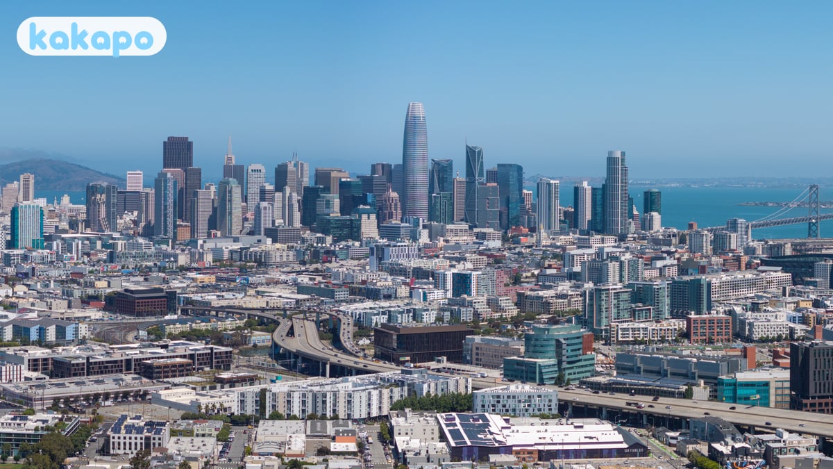
San Francisco is a complicated city to write a safety guide for in 2026 — its reputation has swung between "tech utopia" and "post-apocalyptic" in less than a decade, and the truth sits in the middle.
For tourists in tourist areas, San Francisco is genuinely safe. Crime against visitors is uncommon. The realistic risks for visitors are car break-ins (the city's defining property crime — rental cars with anything visible inside have window-smash rates among the highest in the US), the few-block area of the Tenderloin (open-air drug scene, confronting to walk through but not violent towards passers-by), the cold-summer fog (visitors regularly underestimate how cold July is), and the longer-term Bay Area earthquake context.
The US sits at Level 2 on the UK FCDO advisory list (gun violence, terrorism — generic US-level language). The honest framing for first-time visitors: SF is small (~810,000), surrounded on three sides by water, and walkable in a way few American cities are. Fisherman's Wharf, the cable cars, Golden Gate Bridge, Alcatraz, the Mission, and Chinatown are the visitor anchors.
Visiting San Francisco for the first time, the thing that catches most travellers off-guard isn't crime — it's how thoroughly the post-pandemic narrative diverged from the actual visitor experience. Downtown commercial vacancy hit 35% in 2024, news cycles featured "doom loop" stories monthly, and yet for visitors staying in Union Square, exploring the Mission and walking the bay, the city is overwhelmingly pleasant and safe. Open with "Hi" or "Hey"; tipping culture is real (18-22% at sit-down restaurants, $1-2 per drink at bars); the city is liberal-friendly and welcoming. A coffee at Sightglass or Blue Bottle is $5-7, a Mission burrito at La Taqueria or El Farolito $12-16, a cable car ride $8 (cash or Clipper card), a Tartine bread loaf $11, a casual dinner main downtown $28-40, an Uber from SFO to downtown $45-75.
In 2026, the specific things that have changed since pre-pandemic include: BART tap-to-pay rolled out across every station ($4-12 depending on distance, $11 to/from SFO); Muni Metro and bus tap-to-pay also works ($3 single, $5 day pass); the post-2024 downtown commercial vacancy crisis has produced visible storefront closures around Market Street and the Financial District but also new public-realm investments; the Tenderloin opioid-and-homelessness crisis remains the city's most-visible challenge but is geographically contained to a few blocks; rental-car window-smash crime in tourist parking spots remains epidemic — leave nothing visible, ever; and the post-2024 Lurie mayoral administration (Daniel Lurie took office January 2025) introduced a "Beautify Downtown" initiative with visible results around Union Square.
| Scam / petty-crime risk | Medium |
|---|---|
| Violent crime (tourists) | Low |
| Most common scams | car break-ins in tourist parking spots; aggressive begging in the Tenderloin; open-air drug use in the Tenderloin |
| Safer neighbourhoods | Union Square, Fisherman's Wharf |
| Data sources cited | 4 |
| Last verified |
What the score means — 78/100
- Healthcare (88) — UCSF and CPMC are world-class. Without insurance, ER visits run $1,500-5,000+.
- Air quality (80) — generally clean coastal air. California wildfire smoke episodes (Aug-Oct in bad years).
- Transport (80) — Muni + BART + cable cars; uneven; rideshare is the practical default.
- Personal safety (72) — pulled down by car break-ins and Tenderloin issues, not by violent crime against tourists.
Car break-ins — the safety conversation
- San Francisco's signature property crime: smash-and-grab from parked cars. ~25,000-50,000/year reported (true number is higher; many unreported).
- How it works: organised teams target cars with anything visible inside — bags, phones, jackets, even an empty backpack. The window goes; they grab; gone in 10 seconds.
- Where it happens worst: Lombard Street area, Twin Peaks viewpoint, Palace of Fine Arts, parking lots near tourist attractions, anywhere along Marina Boulevard.
- The defence: leave nothing visible. Empty trunk too. Many SF locals leave the empty trunk-cover up to show "nothing inside".
- Don't pack-and-go at car rental and drive to a sight — drop bags at hotel first.
- Park in attended garages when possible; not free street spots.
- If your car is broken into: file SFPD report online for insurance. Don't expect investigation.
The Tenderloin — the honest description
- Where: roughly bordered by Geary, Market, Polk, and Larkin/Mason. A small district directly adjacent to the Civic Center BART/Muni station.
- What's there: open-air drug use (fentanyl, methamphetamine), homelessness, mental-illness crisis. Confronting to walk through.
- Risk to passers-by: violent crime against tourists in the Tenderloin is rare — the population is overwhelmingly self-harming, not externally violent. Aggressive begging and verbal interactions happen.
- The "Loin" gets brought up by tourists because hotels in the broader downtown sometimes border it; a hotel one block too far west can mean walking through.
- Practical advice: avoid walking through alone after dark. Daytime is generally fine — uncomfortable, not unsafe. Take an Uber/Lyft to your hotel after dark if it's near the area.
- Don't photograph people in distress.
- The adjacent streets (Polk Gulch, Lower Nob Hill, Mid-Market) have improved meaningfully since 2023.
The fog — Mark Twain wasn't joking
- SF summer (July-August): cold, foggy. 14-18°C. The fog ("Karl") rolls in over the Golden Gate most afternoons.
- The contrast: across the bay it can be 32°C in Oakland or Berkeley while SF sits at 14°C in fog. This catches visitors out.
- Bring: a warm sweater + windproof jacket, even in summer.
- Best weather for sightseeing: September-October ("Indian Summer"), and April-May.
Areas — where to stay, where to be aware
Recommended for visitors: Union Square / Nob Hill (central, walkable, hotels), Fisherman's Wharf / North Beach / Russian Hill (waterfront tourist core), Embarcadero / Ferry Building (renovated waterfront), The Mission (food scene, art, Latino culture), Hayes Valley (gentrified café district).
Stay aware: The Tenderloin (see above), parts of South of Market (SoMa) at night (industrial, sketchy after midnight), parts of the Mission at night (around 16th and Mission BART).
SF's notable "unsafe" areas (Bayview-Hunters Point, parts of the Outer Mission) are not on standard tourist itineraries and you wouldn't end up there.
Earthquake context
- The Bay Area: sits on the San Andreas and Hayward faults. Last major event: 1989 Loma Prieta (6.9M, 63 dead).
- Probability: USGS estimates ~70% chance of a magnitude 6.7+ Bay Area quake in the next 30 years.
- Day-to-day risk for tourists: small. Modern hotels are seismically engineered.
- If a tremor hits: drop, cover, hold under sturdy furniture. Stay indoors during shaking; old brick chimneys and exterior walls fall first.
- Tsunami: very low risk for SF (Golden Gate strait blocks most).
Transport, BART, the airport
- Muni: SF's bus + light-rail + cable car system. $3 cash, $2.50 with Clipper card or contactless tap.
- BART: regional rail. Connects SF, Oakland, Berkeley, airports.
- Cable cars: $8 single — touristy + slow, but iconic.
- Uber + Lyft: cheap and ubiquitous. The default tourist transport.
- Waymo (driverless taxis): operating commercially in SF since 2024. Available via app. Different experience.
- Walking: the city is walkable; some routes are very steep — use cable cars or Uber for hill avoidance.
- SFO Airport: BART direct from international terminal, $9.65 to downtown, 30 min.
- Don't drive in SF if you can avoid it: parking is expensive, narrow, hilly, and break-in-prone.
Money, food, the cost story
- Currency: US dollar.
- Tipping: 18-22% in restaurants. 15% in taxis. SF restaurants increasingly add a 5-7% "SF mandate" or "kitchen fee" — this is not a tip.
- Tax: 8.625% sales tax added at register.
- Cards: universal.
- Tap water: excellent (Hetch Hetchy reservoir).
- Cost: hotels $250-500/night standard; mid-range dinner $40-80/person.
Neighbourhood-by-neighbourhood breakdown
- Union Square / Downtown / SoMa — the central tourist and shopping district, cable car turnaround, hotels, Westfield Centre. Daytime busy and safe; some homelessness visible on Market Street; the surrounding blocks east of Market (around 5th-6th and Mission) border the Tenderloin and are scrappier.
- Tenderloin — the few-block district immediately west of Union Square, North America's most visible opioid-and-homelessness scene. Confronting to walk through; not violent towards passers-by; passing through is fine, lingering is not. The transit hub at Civic Center/UN Plaza is the densest spot.
- Nob Hill — uphill north-west of Union Square, the historic luxury hotel district (Fairmont, Mark Hopkins), Grace Cathedral. Very safe.
- Chinatown — west of the Financial District, the largest Chinatown outside Asia, the dragon gate, Grant Avenue. Very safe by day, calmer at night.
- North Beach — north of Chinatown, Little Italy, Coit Tower, Beat-Generation literary heritage. Very safe.
- Fisherman's Wharf — northern waterfront, the touristy Pier 39, sea lions, Alcatraz ferry departure. Very safe day and night.
- The Marina / Cow Hollow — north-west, gentrified, the Marina Green, post-yuppie restaurant strip on Chestnut Street. Very safe.
- The Mission — south-central, the Latinx-and-tech-hipster cultural heart, the best food in SF, Mission Burrito (La Taqueria, El Farolito), murals, Dolores Park. Very safe with normal awareness; some homelessness in the southern parts.
- Hayes Valley — west of City Hall, boutique-shopping and brunch district. Very safe.
- The Castro — south-west, the LGBTQ+ heart of the city, Castro Theatre, Pink Triangle Park. Very safe.
- Haight-Ashbury — west, the 1960s counterculture intersection, vintage shops. Daytime safe and atmospheric; some homelessness; a bit faded from the romance.
- Sunset / Richmond — west, foggy Avenue residential, beachfront Ocean Beach, dim sum on Clement and Irving streets. Very safe.
- Civic Center / UN Plaza — central, City Hall, Asian Art Museum. Architecturally fine; the homelessness density at UN Plaza is the city's most visible.
If it's your first time visiting
- Best arrival airport: San Francisco International (SFO), 21 km south. To downtown: BART train $11 in 30 min direct to Embarcadero, Powell, Civic Center (the standard option), Uber/Lyft $45-75, taxi $50-65. Oakland (OAK) for some cheap flights — 1h via BART transfer.
- Public transport: BART regional rail (5 lines), Muni Metro and buses, cable cars. Clipper card or tap-to-pay on every reader. $3 Muni single, $5 day pass, $11 cable car single. BART connects to airports, Oakland, Berkeley.
- Best neighbourhood for your first night: Union Square for centrality (best hotels), Nob Hill for upmarket, North Beach for atmosphere, Mission for food, Hayes Valley for hip residential. Avoid first-time bookings directly in the Tenderloin or just east of Market between 5th-7th.
- Day 1, jet-lag friendly: drop bags, lunch at the Ferry Building or in the Mission (Mission burrito at La Taqueria $12-15), cable car ride from Powell to Lombard ($8 — the iconic experience), evening walk along the Embarcadero to the Ferry Building, dinner at a Hayes Valley restaurant.
- Day 2 essentials: Alcatraz ferry (pre-book 6-8 weeks ahead, $45-50 — the city's most essential booking), Golden Gate Bridge by bike (Blazing Saddles or Sports Basement rental), Mission murals walk, Dolores Park sunset, dinner in the Mission.
- Day trips: Muir Woods and Sausalito (1h north), Wine Country (Napa or Sonoma 1.5h north), Half Moon Bay (1h south), Yosemite (4h east — overnight better), Berkeley and Oakland (BART, 30 min).
- Common rookie mistakes: leaving ANYTHING visible in a rental car (window-smash is endemic — empty everything including loose change and shopping bags); wearing shorts in July (SF summer is the foggiest, coldest summer of any major US city); booking Alcatraz on arrival day (sold out 6-8 weeks ahead in season); walking through the Tenderloin at 11pm to "save Uber money"; renting a car at all if you're staying in the city (parking is a nightmare and break-ins are the rule).
- For the cold-fog summer: pack layers, a windproof jacket, long pants. SF July averages 18-20°C with fog (locals call it "Karl"). Indian summer (September-October) is actually the warmest, sunniest season.
- Tap water is excellent (Hetch Hetchy from Yosemite). Drinkable everywhere.
Practical info — emergency numbers
- Emergency: 911.
- SFPD non-emergency: 415-553-0123.
- UCSF Medical Center ER: 415-353-1037.
- Travel insurance: not optional. Without it, an ER visit costs $1,500-5,000+.
Bring: layered clothing including a windproof jacket (even in summer), comfortable walking shoes, an unlocked phone (T-Mobile, AT&T, Verizon prepaid SIMs), and US-valid travel insurance with full medical coverage. Don't leave anything visible in a parked car.
Frequently asked questions
Is San Francisco safe to visit in 2026?
Yes, with honest caveats — San Francisco scores 78/100 here. The US sits at UK FCDO's lowest advisory tier overall. Violent crime against tourists is genuinely rare; SF's reputation problem is driven by visible open-air drug use and homelessness in specific neighbourhoods (Tenderloin, parts of SoMa, parts of the Mission near 16th/Mission BART) rather than by tourist victimisation. The reality: stay in FiDi/Embarcadero/North Beach/Marina/Hayes Valley and you will see a remarkable city. Walk through the Tenderloin between Powell BART and the Civic Center at the wrong time of day and you will see scenes that are upsetting and unlike anywhere else in the developed world. Both things are true. The dominant property crime is car break-ins ('bipping') — never leave anything visible in a rental car.
Is San Francisco safe at night?
Depends entirely on where. FiDi, Embarcadero, North Beach, Marina, Hayes Valley, Castro, inner Mission (Valencia Street) — fine at night and busy with locals. Tenderloin, the blocks of SoMa south of Mission between 5th and 10th, parts of Mid-Market, and the immediate area around 16th & Mission BART — avoid on foot after dark. The cable cars stop running at midnight; Muni Metro and BART run until midnight-ish (BART until 21:00 on Sundays). Uber/Lyft are reliable and the realistic late-night option. Don't take BART from SFO airport late at night with luggage — fentanyl smoke on platforms and trains is a documented problem; use the airport shuttle or rideshare instead.
What about the open-air drug use — is it as bad as the YouTube videos?
In the worst three or four blocks of the Tenderloin and on Hyde Street between Eddy and Turk, yes — the YouTube videos are real, not staged. Open fentanyl smoking, public injection, and people in serious medical distress on the sidewalk are visible reality during the day. The honest framing: this is concentrated in a roughly 10-block area, the City and SFPD have shifted to a more enforcement-heavy approach since 2024, and most tourists never need to walk through it. If you're staying at Union Square, just exit toward Market Street and Powell BART rather than walking west through the Tenderloin. It is not a danger to you in the violent sense; it's a public-health emergency you can choose to avoid encountering on foot.
What scams and crimes should tourists actually worry about?
Car break-ins are #1 by a huge margin — SF has the worst rental-car-bipping rate in the US; thieves smash windows in broad daylight in 30 seconds, especially around Lombard Street, Twin Peaks, Sutro Baths, and Lands End trailheads. NEVER leave anything visible. Phone-snatch on the Embarcadero and at Powell cable car turnaround is moderate. The classic 'shell game' operators near Fisherman's Wharf still operate. Genuine scams are uncommon; SF is a high-property-crime city with low person-on-person tourist crime. Use Apple Pay/contactless rather than carrying a wallet; keep your phone tethered to your wrist on cable cars and at viewpoints.
Can you drink tap water, and how do cable cars / Muni Metro / BART work?
Tap water — yes, famously excellent: SF water is drawn from Hetch Hetchy in Yosemite via gravity-fed aqueduct and is some of the cleanest in the US (refill stations at Ferry Building and Crissy Field). On transit, three overlapping systems: cable cars (Powell-Hyde, Powell-Mason, California Street) are $8 per ride; queue at the Powell turnaround can be 90+ minutes — ride from the California Street end to skip lines. Muni Metro (J/K/L/M/N/T) is the city light rail, $2.50 with Clipper. BART is the regional heavy rail connecting SFO to Powell/Embarcadero/Civic Center (~$10 from SFO, every 15-20 minutes, runs until ~midnight weekdays). Buy a Clipper card on day 1 — works on all three plus the ferries. Avoid BART from SFO late at night; use rideshare instead.